Archaeological Investigations on the Island of Lastovo, Croatia:
Preliminary Report
Philippe Della Casa & Bryon Bass _ Dept. of Prehistory, University of Zurich / Branko Kirigin _ Archaeological Museum Split / Dinko Radic _ Museum Vela Luka
2. The Island of Lastovo
Location and Geography
Archaeological Situation
3. Survey (2001 Lastovo Expedition)
4. Sub-surface Investigations (2003 Lastovo Expedition)
Lucica
Kastel
Abstract
This paper provides a progress report of the investigations by the Korcula Archaeological Research Group (KARG) on the south Dalmatian island of Lastovo (Croatia). The KARG initiated research on Lastovo with a field survey in 2001, and followed with test excavations on two pre- and protohistoric sites during 2003. Materials from these sites suggest settlement and maritime trading activities in the vicinity of today’s Lastovo town from the 2nd millenium BC through Hellenistic and Roman times. The exact location and nature of the settlements in and near Lastovo town has yet to be established.
1. Introduction
The 2001 and 2003 Lastovo Expeditions were conducted by the multinational KARG team, in cooperation with the Regional Service for the Protection of Monuments in Dubrovnik. Members of this team have been leading archaeological field research in southern Dalmatia since 1993, including in particular work on the islands of Korcula and Susac (e.g. Bass 1997, 1998; Bass et al. 1997; Della Casa & Bass 2001; Radic et al. 1998, 2000; Radic and Bass 1999, 2001, 2002). The field seasons were organized as separate campaigns that addressed specific issues within the general framework of the KARG research topics. All archaeological materials collected were processed immediately following fieldwork, and a complete record of activities is maintained in the KARG facilities at the Archaeological Museum in the town of Vela Luka, Korcula.
2. The Island of Lastovo
The island is known from antique written sources under the name of Ladesta or Ladeston (Steph. Byz. 405 referring Theopompos of Chios). It was given the name “Augusta insula” during Roman times, appears as Insula Ladestris on the Tabula Peutingeriana, and in Medieval sources as Augusta, Lagusta or Lagosta. The slavic form of the name – Lastobon, Lastovo – became current from the 10th century AD (see Jurica 2001; Migotti 1987; Radmilli 1970).
Location and Geography
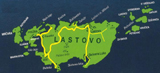
Lastovo lies around 30 nautical miles off the Dalmatian coast, within an archipelago of 46 smaller islands between Mljet, Korcula and Susac. The island’s surface covers 47 sq. km. Presently, approximately 800 people inhabit the island. Most live in Lastovo town to the north (facing the island of Korcula) or in the modern ferry harbor town of Ubli, situated on the western side of the island (Figure 1).
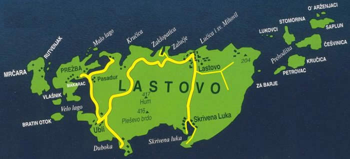
Fig. 1. Map of the island of Lastovo with main roads and localities (Lastovo tourist board).
The island has a number of sheltered bays and natural harbors, among them Velo and Malo lago, Krucica, Zaklopatica, Lucica and Skrivena luka (Figure 2), suitable for anchorage. The geographical setting and favorable Mediterranean climate, with average annual temperatures of 15 °C and annual rainfall around 700 mm, offer excellent conditions for permanent settlement on the island.
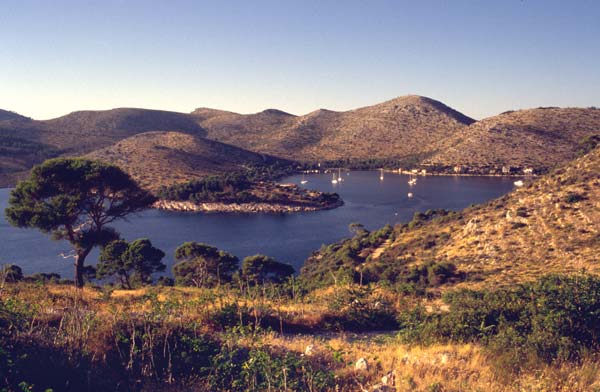
Fig. 2. Skrivena luka, from the lighthouse (PDC).
The island’s geology comprises a Dinaric fault within an Upper Jurassic formation, with the highest elevation situated at 415 meters a.s.l. on Hum. The Karstic relief is rugged for most of the island surface, and agricultural ground is limited primarily to the terra rossa polja (valleys) such as Nizno and Vino polje close to Ubli, and Lokavje, Przina and Prgovo near Lastovo town. The island is famous for its fruit, vine and olive orchards. Larger parts of the island are still covered by natural pine and evergreen oak forest. Numerous caves are known around the calcareous slopes of the polja, some of which were occupied during prehistoric times. The island’s coastline is fairly steep, and the surrounding sea deep and rich in maritime food resources such as fish, crustacea, and shellfish.
Archaeological Situation
Investigations into the archaeology of the island of Lastovo began back to the 1930s and 40s (Tamino 1937; Galli 1938; Radmilli 1955) while some of the caves, in particular Spilja Raca (Gambero Cave), had already been visited and described earlier on (Senoa 1916). Radmilli excavated a trench in Spilja Raca in 1942 and reported finding Neolithic, Bronze and Iron Age ceramic materials (Radmilli 1970). The cave was later investigated by Gjivoje (1951), and finally by Novak in 1953 who published general stratigraphic information and finds attributable to the late Neolithic (Hvar Culture), Early Bronze Age, Iron Age, Hellenistic, Roman and Medieval periods (Novak 1955; 1973). Monuments of the Classical, Early Christian and Medieval periods have been extensively described by Fiskovic (1966). The most detailed analysis of pottery from Greek and Hellenistic times (from Spilja Raca) was conducted by Migotti (1987). Until Croatia formally separated from the former Yugoslav Republic in 1991, the island was considered a naval base and was essentially closed to visitors from abroad. Archaeological sites were visited by Croatian officials in the latter part of the 20th century, but their work has remained unpublished. There is in particular no report of an archaeological map pertaining to the island of Lastovo.
3. Survey (2001 Lastovo Expedition)
The KARG team led its first survey expedition to the island in the summer of the year 2001. The aims were to relocate previously known archaeological sites, document previously unrecorded archaeological sites, to collect and/or record temporally diagnostic archaeological materials, and to start the compilation of the island’s cultural heritage in view of a map of archaeological sites (prehistoric to classical periods, to be extended to the early Medieval period in future). The survey focused on specific geomorphological situations such as caves, hilltops, natural terraces and passages or bays with pebble beaches, while systematic field walking was limited to small accessible areas within the polja. The initial field survey was limited to Ubli and its surroundings, the northern coast, Lastovo town and the surrounding polja, and the area of Skrivena luka.
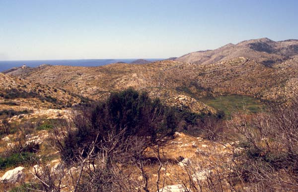
Fig. 3. Topographical location of Spilja Raca (PDC).
Among the sites relocated/recorded are caves such as the afore mentioned Spilja Raca (Figure 3), hilltop and hillslope settlements (Kastel above Lastovo town, Sozanj), a harbor bay site (Lucica), Roman villas (Skrivena luka, Barje) and a Roman water pond in the Lokavje polje (Figure 4).
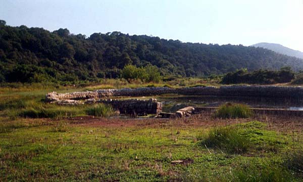
Fig. 4. Roman walls on pond in Lokavje polje (Seth Button).
A total of 22 archaeological sites were recorded during the initial field survey. Three sites were previously known from the literature review, while nineteen were detected through the field survey. Seventeen sites are roughly datable to prehistoric (Neolithic–Iron age) and 5 to protohistoric (Greek/Hellenistic–Late Roman) periods. However, these results should be considered preliminary until a more extensive field survey is conducted.
4. Sub-surface Investigations (2003 Lastovo Expedition)
Following the first campaign and its encouraging results, the KARG team initiated sub-surface testing at two previously documented sites, parallel to the resumption of the archaeological field survey. Both sites chosen for the 2003 test excavations, Kastel and Lucica, lie in the proximity of Lastovo town. The hilltop Kastel, culminating at 188 m a.s.l., rises above Lastovo town and overlooks both the fields to the south and the adjacent coast and islands to the north (cf. Figure 7). The small bay of Lucica, together with Sv. Mihovil bay, represents the closest and easiest access to the sea from Lastovo town. It can thus be assumed that for any settlements on or around Kastel (and Lastovo town), Lucica or Sv. Mihovil would have provided the most proximal harbor and maritime refuge.
Lucica
The 2001 survey detected prehistoric pottery from a number of locations in and around the actual harbor village of Lucica (Figure 5), mostly from garden terraces. The suspicion that the pottery had been transported to these locations together with earthen fill for the gardens proved to be right, as confirmed by interviews with a number of local inhabitants. Therefore, the objective of the sub-surface tests was to locate any primary contexts of archaeological material, as opposed to the secondary depositional contexts previously noted on the terraces.
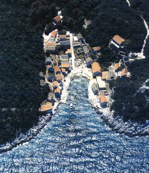
Fig. 5. Lucica harbor bay (Lastovo tourist board).
Five locations around Lucica were considered for sub-surface testing. Three locations (LAL1–3) were tested by small trenches (1 or 2 sq. m), one garden yard was surveyed for surface pottery samples (LAL4), while another site – a profile cut into the embankment of the asphalt access road leading to Lucica bay (LAL5) – was cleaned, documented, and probed.
Though all the test trenches were dug down to sterile B-horizons, none produced in situ archaeological layers. Prehistoric finds (e.g. pottery, flint) were present, but always mixed with other materials in secondary deposits. This is probably due to erosion and geomorphologic processes on the slopes and terraces around Lucica, and to substantial reworking of the natural terrain by building activities and roadworks during the 19th and 20th centuries.
The embankment profile LAL5 illustrates the situation quite well, and shows a clear stratigraphic inversion, as confirmed by sedimentological analysis and radiocarbon dates obtained from the profile (Figure 6). While the lower part of the sequence consists of natural soils (B-horizon), the overlying thick ash and charcoal layers containing iron ores (e.g. limonite) possibly indicate local mining and iron working activities in the 14th/15th cent. AD. Naturally, this observation requires confirmation via historical literary sources. In the upper part of the profile, the heterogeneous organic dark strata are in secondary position. This stratum produced two radiocarbon dates calibrated 700-350 BC (single charcoal AMS) and pottery of prehistoric to Roman age. A layer of natural sedimentation (A-horizon) tops the sequence.
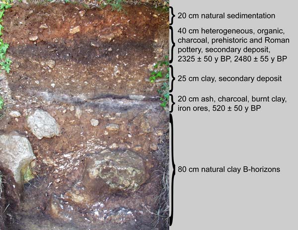
Fig. 6. Lucica LAL5 profile and description (PDC).
With the exception of two Roman fragments from LAL5, the pottery recovered in the various tested locations is of prehistoric manufacture. It is handmade with rough or smoothed surfaces and calcite/limestone temper. Plastic decorations such as trims, lugs, and digit impressions occur (cf. Figure 9). Several undiagnostic fragments of retouched flint were collected in LAL3.
There can be no doubt from the materials collected that the bay of Lucica and the nearby slope terraces were settled and/or occupied from the 2nd/1st millennium BC, and possibly even earlier if the flint finds are considered. The exact location and nature of these settlements however could not yet be disclosed.
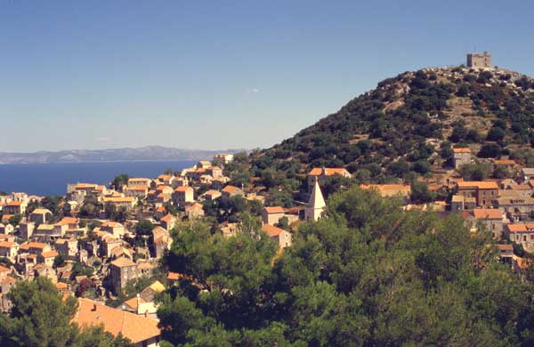
Fig. 7. Kastel hill above Lastovo town (PDC).
Kastel
Two locations on the slopes of Kastel (Figure 7) were sub-surface tested. Excavations at one location were terminated when a concrete structure was encountered at the base of the primary test unit. The testing along the southern slope of Kastel (Figure 8) yielded more diagnostic materials, primarily from the Hellenistic and Roman periods. However, these tests were terminated when a limestone outcrop was encountered within the unit. In both locations at Kastel, all excavated archaeological materials were sampled from secondary depositional contexts. Sterile soils and reliable stratigraphy were not observed at either location.
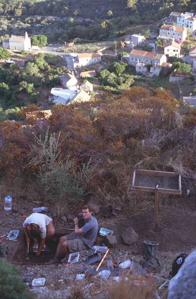
Fig. 8. Kastel test unit 2 (PDC).
The prehistoric pottery recovered from the two test locations on Kastel generally derives from Bronze and Iron Age activities and occupations in and around the hilltop (Figure 9). A few weathered pottery fragments might derive from later Neolithic/Copper age periods.
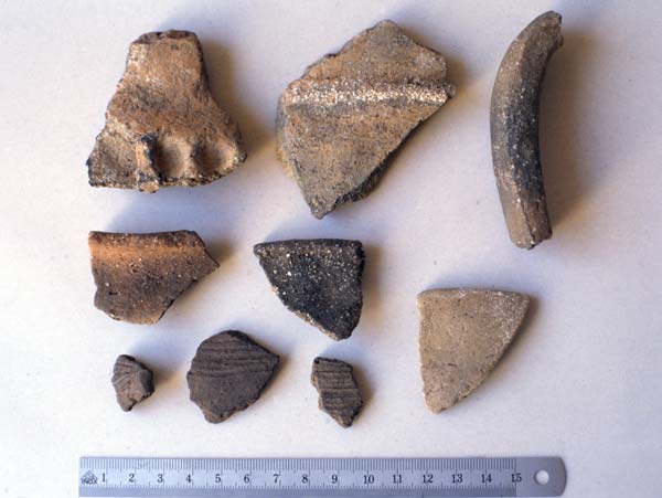
Fig. 9. Kastel, prehistoric pottery from surface and sub-surface collection (PDC).
The majority of the pottery derives from the Hellenistic and Roman periods. Most appears to be from the period of the later Roman Republic, as indicated by diagnostic pottery fragments and one coin minted at Julius Caesar’s colony at Corinth (Figure 10). This coin dates to the early 40s AD and examined along with the fine ware pottery, provides a general temporal indicator for Roman activities at Kastel. The amphorae fragments (course wares) are temporally consistent with the fine wares, and also indicate Hellenistic and early Roman Imperial activities in the general area of Kastel and Lastovo town.
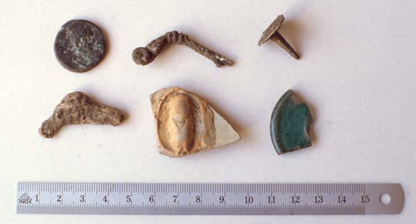
Fig. 10. Kastel, Roman finds from test unit 2 (PDC).
5. Results and Prospects
The preliminary excavations have provided insights into important themes of archaeological research in the Adriatic Sea. Bronze Age maritime activities are just now being explored in the eastern Adriatic, and harbors dating to that period are relatively undocumented in this part of the Mediterranean Basin. The survey and test excavations at Lucica provide some of the first, albeit preliminary, insights into Bronze Age shoreline archaeology. Kastel has yielded materials from both prehistoric and protohistoric periods and provides a general baseline for activities in and around the hilltop, Lastovo town, and the surrounding fields.
Future KARG research and publications concerning Lastovo will shed light on these and other important prehistoric and protohistoric research topics. The first test excavations have revealed valuable archaeological and historical data on one of more pristine, yet academically overlooked, Croatian islands. Continued sponsorship of projects in this unique cultural area within the Mediterranean Basin will be of direct benefit to both the local communities as well as the greater international academic community.
Acknowledgements
The KARG maintains a research station at the Centar za kulturu / Arheoloski muzej, in the town of Vela Luka on the island of Korcula. The authors would like to thank the Opcina Vela Luka for their invaluable and continued support. They are very grateful for an International Research and Exchanges Board (IREX) Short-Term Travel Grant, obtained through the University of California, Berkeley (Institute of Slavic, East European and Eurasian Studies) for the 2001 Lastovo season, and to the Kommission zur Foerderung der wissenschaftlichen Forschung an der Universitaet Zuerich for the financial aid to the 2003 season. The team also appreciates the continuing support of Nissan Switzerland for providing field research vehicles. Sedimentological analysis on LAL5 was done by Philippe Rentzel, University of Basel; 14C dates were provided by the Radiocarbon Laboratory of the University and ETH of Zurich. The team members of the 2001 and 2003 Lastovo Expeditions were, along with the authors of this report: Zoe Bass, Tea Katunaric, Seth Button, Dan Shoup, Renata Huber, Emanuela Jochum Zimmermann, and Dan Bee.
Bass, B. 1997.
An archaeological assessment of the prehistoric and protohistoric evidence from the island of Korcula. Ph.D. Dissertation. Department of Archaeology, University of Edinburgh, Scotland.
Bass, B. 1998.
Early Neolithic offshore accounts: remote islands, maritime exploitations, and the trans-Adriatic cultural network. Journal of Mediterranean Archaeology 11/2: 37-62.
Bass, B., Radic, D. and Kirigin, B. 1997.
Susac 1997. Obavijesti Hrvatskog arheoloskog drustva 29/3: 70-72.
Della Casa, P. and Bass, B. 2001.
Archaeological Evidence from the island of Susac, Croatia: Preliminary Report. http://www.prehist.unizh.ch/forschung/susac
Fiskovic, C. 1996.
Lastovski spomenici, Prilozi povijesti umjetnosti u Dalmaciji 16 (Split), 5-152.
Galli, E. 1938.
Lagosta, nuove scoperte archeologiche nell’isola. Atti Accad. Naz. Lincei ser. VI, vol. XIV (Roma).
Gjivoje, M. 1951.
Spilja Raca na otoku Lastovu. Nase planine 3(6), 154-159.
Jurica, A. 2001.
Lastovo kroz stoljeca. Lastovo: Matica hrvatska Lastovo.
Migotti, B. 1987.
Otok Lastovo u dodiru s grckim svijetom. Arheoloski radovi i rasprave 10 (Zagreb), 133-153.
Novak, G. 1955.
Arheoloska istrazivanja na otocima Lastovu i Korculi u 1953 godini. Ljetopis JAZU 60 (Zagreb), 227-230.
Novak, G. 1973.
Spilje na otocima srednjeg Jadrana kao prebivalista, sklonista i svetista u prethistoriji. Actes du IVe Congrès International de Spéléologie en Yougoslavie 1965 (Ljubljana), 119-140.
Radic, D. and Bass, B. 1999.
Current archaeological research on the island of Korcula, Croatia. Vjesnik za arheologiju I historiju dalmatinsku 90-91: 361-403.
Radic, D. and Bass, B. 2001.
Gradine otoka Korcule (Pretpovijesne structure na vrhovima Korculanskih brda). Izdanja, Obavijesti Hrvatskog arheoloskog drustva 20: 133-145.
Radic, D. and Bass, B. 2002.
Back to the current Greek reality on Korcula: the ground situation reviewed, new evidence, and future investigations. In N. Cambi, S. Cace and B. Kirigin (eds.), Greek Influence Along the East Adriatic Coast, Proceedings of the International Conference (Split, Croatia, 24-26 September 1998): 289-302 (Split).
Radic, D., Bass, B. and Della Casa, P. 1998
Arheoloska istrazivanja na otoku Suscu: sezona 1998. Obavijesti Hrvatskog arheoloskog drustva 30/3: 55-59.
Radic, D., Bass, B. and Della Casa, P. 2000.
Arheoloska istrazivanja na otoku Suscu: sezona 2000. Obavijesti Hrvatskog arheoloskog drustva 32/3: 59-62.
Radmilli, A.M. 1955.
La isola di Lagosta nella preistoria. In: Comitato Scientifico Sez. Modena C.A.I. (ed) Volume unico in memoria del Prof. F. Malavolti (Modena).
Radmilli, A.M. 1970.
The Island of Lastovo from Prehistory to the Roman Era. Adriatica Praehistorica et Antiqua (Zagreb), 439-446.
Senoa, M. 1916.
Spilja Raca na Lastovu. Glasnik Hrvatskog prirodoslovnog drustva (Zagreb).