The Leventina (Ticino, CH) Prehistoric Settlement Landscape – GIS-based analysis of geomorphological, archaeological and ecological data
Martin Sauerbier, Philippe Della Casa, Christiane Jacquat
Dept. of Prehistory, University of Zurich
Following the discovery and partial excavation of a Bronze and Iron age site in Airolo-Madrano (TI), the Department of Prehistory of the University of Zurich engaged in a new settlement and landscape archaeology project in 2006 which aims at the reconstruction and modeling of environemtal, economic and social factors involved in prehistoric colonization processes in the Alpine Ticino valley. The project uses an interdisciplinary archaeological/ biological/ geographical/ geomatical approach and an individually designed GIS database to address issues of site location and topography, site catchement, economic structures, travel routes and social interaction. Some first stage analysis is presented in this preliminary report.
The SNF project “Leventina – Prehistoric Settlement Landscape” (2006–09) aims for a reconstruction and analysis of the prehistoric Bronze and Iron age landscape in the Leventina valley (TI) with focus on settlement and land use investigations in an alpine region. The project can be regarded as a continuation of a number of projects conducted by the Department of Prehistory of the University of Zurich since 1985 dealing with settlement and landscape studies in alpine areas (Figure 1). Concerning its geographical extent, it completes a regional network spanned by the various projects in central and east Switzerland.
Such a study – comprehensive in terms of data and required knowledge – can only be accomplished successfully within the frame of an interdisciplinary project. Therefore, scientists from the fields of archaeology, archaeobotanics, geography and geomatics engineering from the University of Zurich and ETH Zurich are involved in the research. The goal is to include data and methods from these disciplines to achieve an integrated analysis of the factors that had an impact on settlement distribution, population and agricultural land use during the Bronze and Iron ages.
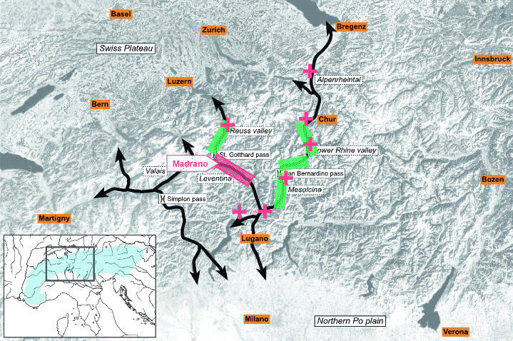
Fig. 1: Projects of the Department of Prehistory UZH, 1985 – 2007. |
Due to the fact that most of the data describing the aforementioned factors is spatially related, we develop a GIS (Geographic Information System) database, which can store spatial and attribute data, for our purposes. Various data from different sources and at different resolutions are currently being integrated and are available for preliminary analysis. In a first step, we acquired the spatial and thematic data listed below:
- Digital Terrain Models (DTM) provided by Swisstopo, namely DHM 25 and DTM-AV (derived from airborne laser scanning)
- SRTM 90m (Shuttle Radar Topographic Mission), the world-wide DTM generated from RADAR measurements conducted during a NASA shuttle flight
- Scanned topographic maps from Canton Ticino at a scale of 1:10'000, which were georeferenced
- Scanned maps with climatological, soil and geological layers, also georeferenced
- Orthoimages SWISSIMAGE from Swisstopo with a footprint of 50 cm
- The find database from Canton Ticino (”archaeological map”), including coordinates
- Digital Topographic Maps from Swisstopo
- Tachymetric 3D point measurements of the prehistoric settlement of Madrano for highly detailed terrain modeling
For the integration of archaeological and further data in the GIS database, a conceptual data model was designed using UML (Unified Modelling Language); the core of the model is shown in figure 2. After implementation of the data model, it will be possible to join archaeological data to spatial data and to conduct queries on both types of data.
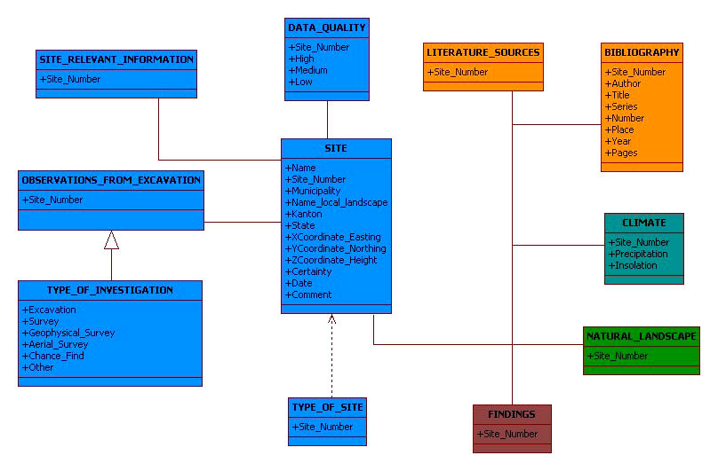
Fig. 2: UML data model for the GIS database. |
GIS-based analysis was performed in a first approach to answering the following questions:
- Which areas were used for agriculture by the inhabitants of prehistoric settlements? How were they most likely used?
- Which routes across the alpine mountain ridges served possibly as North-South connections for trade or other purposes?
- Why did people settle at certain locations?
While the first issue can be investigated by means of site catchment analysis and spatial statistics, e.g. factor analysis and predictive modeling, the second can be studied by means of cost surface analysis and for the third issue, visibility studies are, among others, one method which can yield significant results.
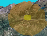
Calculation of site catchments in our case aims for the determination of agricultural areas used by the inhabitants for farming. We can assume that the spatial distribution of these areas with respect to the settlement depends on various factors which have to be taken into account, such as travel time from the settlement to the agricultural land, soil properties, accessibility, rainfall, temperature, terrain slope and others more. In a first approach, we calculated a simple site catchment based on the distance to the settlement, which resulted in two radial catchments around Madrano, of which one covers the area in 1km radius and one in 5 km radius around the pre historic settlement. Figure 3 shows a 3D view on the terrain, overlaid with an orthoimage and the two catchment areas.
Currently, we work on the integration of the aforementioned factors to achieve more reliable catchment areas. We evaluate the impact of these factors, using modern land use classification as ground truth, by means of factor analysis. This method allows us to reject certain unsuitable areas directly from the calculation and to distinguish between different types of land use. Furthermore, a consideration of the different factors in one mathematical model will be enabled.
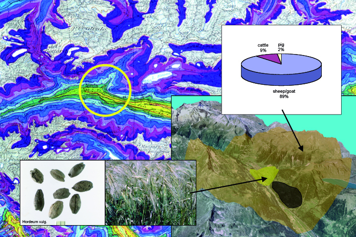
Fig. 3: Circular catchment around Madrano (1 and 5 km), with potential zones for agriculture, stock breeding, and forestal economy. Background: phenological map of Switzerland by Swisstopo. |
A well-known application of cost surface analyses is least cost path calculation, mostly based on terrain slope values. For the determination of advantageous routes across the main alpine ridges, we investigate different alternative routes which were digitized based on still existing pathways (Gotthard) or routes which are assumed for earlier times due to finds (Figure 4). Based on terrain slope, the cost required to travel from A to B can be summed up and compared for different routes. In an exemplary manner, we compared two alternative routes from Bellinzona to Altdorf (see the blue and orange marked routes in figure 4). As a result, we found that the Gotthard route requires ca. 18% less effort to travel from Bellinzona to Altdorf compared to a route crossing two alpine passes. For future investigations, we will determine the costs for further routes based on travel time, which can be regarded as a function of slope, in order to compare also the travel durations.
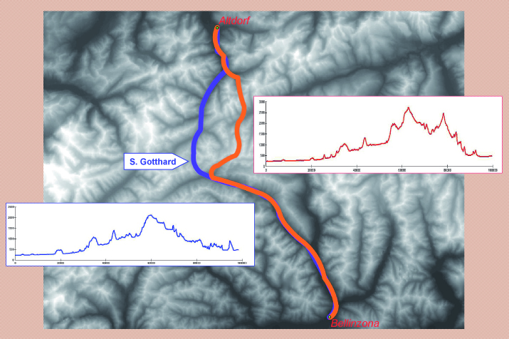
Fig. 4: Comparison of travel cost from Bellinzona to Altdorf – two alternative routes. |
Visibility studies provide a suitable method to investigate topographic properties of a certain location. Especially in mountainous terrain, visibility may have played an important role for the decision of where to build a settlement. Control of trading routes requires observation points with a high visibility; figure 5 shows an exemplary calculation of the viewshed for Madrano, the areas marked in red are visible from Madrano. It is noticeable that the valley ground is not visible from the settlement, though the mountain slopes are. Presumably, this coincides with the course of ancient pathways as the valley ground was completely covered by the river meanderings.
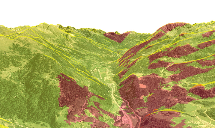
Fig. 5: Viewshed from Madrano to southeast direction. |
In the next stages of the project, the different approaches to locations and connections of archaeological settlement sites must be criticized and refined. This concerns in particular the introduction of higher resolution soil and climate data for site catchment, realistic ground travel parameters for travel route analysis, and comparative modeling for site topography. Likewise, the archaeological background data are being expanded through field surveys with in- and off-site investigations in various altitudinal locations of the valley floor, slope terraces, mid-mountain and alpine pastures, as well as of the central alpine pass routes.
The Project is funded by the Swiss National Foundation for Scientific Research (SNF), number 100012-111987. We are most grateful to Rossana Cardani Vergani, Giuseppe Chiesi, and the welcoming aid by the Ufficio dei beni culturali, Bellinzona, as well as the technical support granted by the Chair of Photogrammetry and Remote Sensing at ETH Zurich.
JbSGUF 87, 2004; 88, 2005; JbAS 89, 2006; 90, 2007.
Jochum Zimmermann, E., Wiemann, Ph., & Della Casa, Ph. (2006) Erster Vorbericht über die archäologischen Untersuchungen in Airolo-Madrano (2003–05). Online-Artikel: www.prehist.uzh.ch/onlineart/Airolo-Madrano.htm