The Geoglyphs of Palpa (Peru): Documentation, Analysis, and Interpretation
von Karsten Lambers
Abstract: The coastal Peruvian desert around Nasca, ca. 450 km south of Lima, is covered by thousands of geoglyphs or "Nasca lines". These large-scale drawings on the desert floor, representing biomorph and geometric figures, long straight lines, and large cleared areas, were made during the time of the Nasca culture (200 BC - AD 600) and are nowadays one of the most famous touristic sites in Peru.
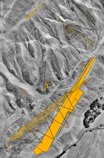
In spite of their importance, the Nasca lines are still poorly understood in terms of context and meaning. This is largely due to the lack of an adequate documentation. In the framework of the Nasca-Palpa Project of SLFA, Zurich, more than 1500 geoglyphs around Palpa, to the north of Nasca, have been photogrammetrically recorded and modeled in 3D. All geoglyphs and other cultural remains (e. g., settlements, cemeteries) were furthermore registered in the field.
The present project comprises an archaeological analysis of the resulting data on the Nasca lines at Palpa. A GIS established at ETH Zurich is used to analyze the spatial relations between the geoglyphs and their cultural as well as natural environment. The aim is to understand the role of the geoglyphs in the Nasca cultural landscape.
Publikation(en): Lambers, K. (2006)
Weiterführende Links: www.lindensoft.de/Palpa/index.html